
How a Layered Coastal Defence Responds to Conditions
About this practice test
A technical briefing explains how six coastal-defence regions divide the work of absorbing waves, storing runoff, controlling river water and pumping during compound conditions.
What you’ll practice
Finding detail
Locate specific information and evidence.
Interpreting ideas
Connect main points and inferences.
Evaluating arguments
Assess claims, evidence, and limitations.
What to expect:
1 question with explanations to review after submission.
Study the questions and tasks
Work through the material below, or start the interactive practice above to complete an attempt. Try the exercises before opening any answer or transcript sections, then use them to review your work.
- Practice level
- C2. Try this level if you can follow the instructions and understand most of the language; choose an earlier level if you need more support.
- Question formats
- Label the image
How to approach this practice
Read the passage for its main idea, then return to the relevant sentence or paragraph for each question. Base answers on the passage.
How a Layered Coastal Defence Responds to Conditions
 region-1
region-2
region-3
region-4
region-5
region-6
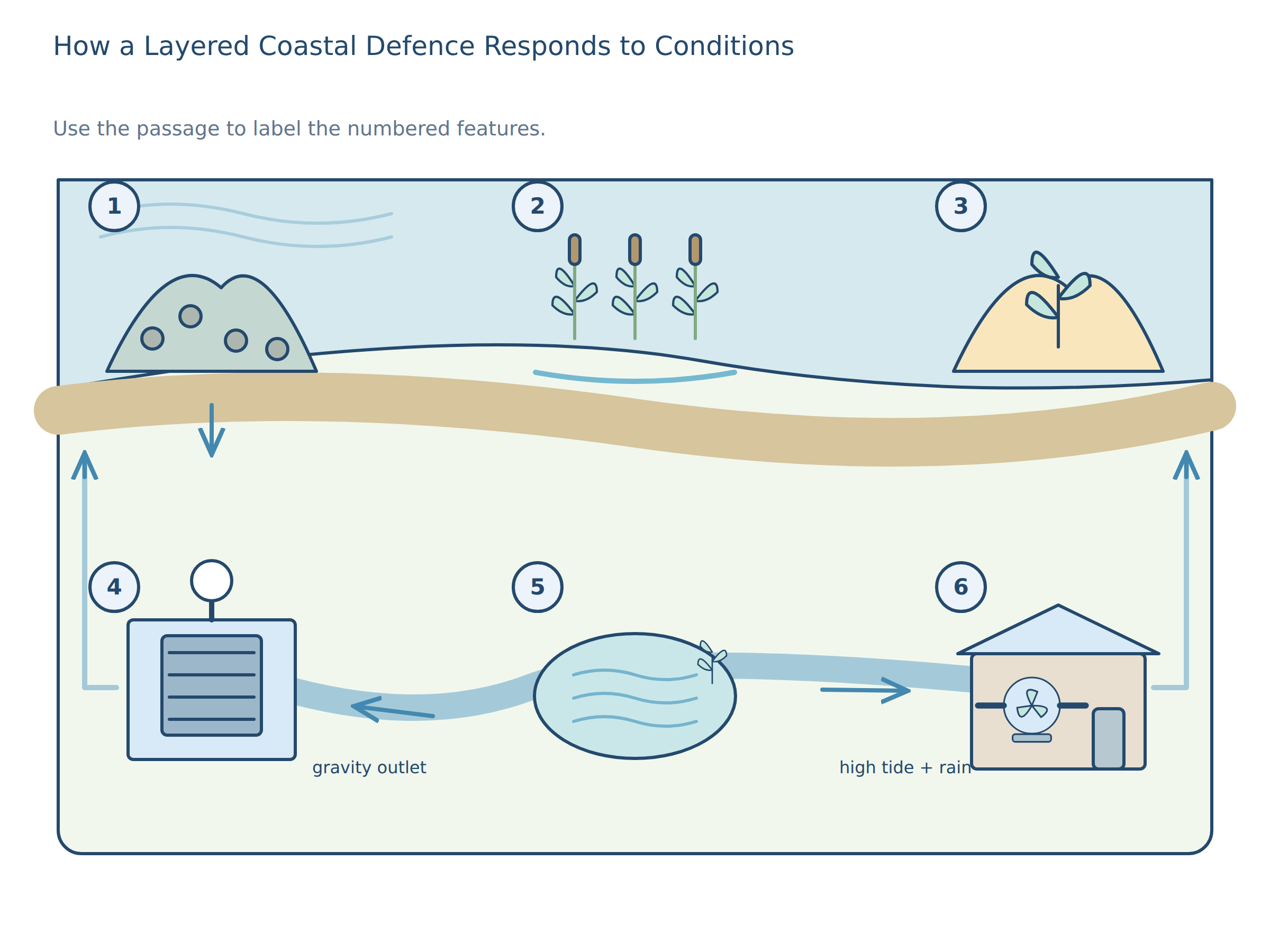
People often imagine coastal defence as a single wall, but the scheme in this passage was designed on the opposite assumption: that the sea changes, and that a good response changes too. Mira Lenz, who coordinates the estuary works, says that a barrier which looks strong in calm weather may become brittle in a storm, while a softer measure may become more useful after the first wave has already spent some of its energy. The aim, then, is not heroic resistance at every point. It is controlled delay, redirection, storage, and release. The plan has two rows, each presenting a different response to water. At the upper left, a rough structure in the open sea reduces the energy of incoming swell before it reaches land. The upper centre holds the planted tidal area that absorbs and slows water, while the upper right is the sandy ridge whose height provides a reserve against overtopping. The lower row contains the active controls: at the left is the opening whose timing depends on tide levels; the middle offers temporary storage when release is unsafe; at the right, machinery moves excess water when gravity cannot. These roles must be distinguished because waves, rainfall and river flow cannot be managed by one structure alone. The offshore reef is the first contact point for incoming swell. It is low enough to be hidden at high tide, but rough enough to break the shape of the wave before it reaches the shore. During ordinary weather it does not look impressive, which is precisely why it works quietly; it removes energy before people notice a crisis. In a severe storm, however, the reef is not expected to solve the problem. It only buys time, trimming the height and speed of water so that the later layers have something manageable to work with. The tidal marsh in the upper centre behaves differently. Instead of rejecting water outright, it welcomes some flooding and then holds it briefly among reeds and shallow channels. That small act of patience is not sentimental; it slows the retreat of the water and gives sediment a chance to settle. Over months, the marsh surface can rise a little, which helps it keep pace with sea-level creep. Yet this benefit depends on careful maintenance. If the marsh is cut off from fresh sediment for too long, it can become waterlogged and thin out rather than thicken. At the upper right, the dune ridge is the most visible landform and the least subtle. It catches spray, traps blown sand, and forms a dry crest above the most common tide line. Visitors sometimes think the ridge is a natural wall, but part of it is deliberately reshaped after every winter so that the wind can rebuild what the storms have stolen. This is a defensive feature that accepts erosion as part of its life. If the sea pushes farther than expected, the ridge may be overtopped, but even then it reduces the violence of the first impact. The lower left sluice gate is the system's decision point. When the river is lower than the sea, the gate opens and lets freshwater escape under gravity. When the sea rises, the gate closes before salt water can travel inland. This is a simpler device than the reef or marsh, but it has less forgiveness: a delayed closure can send brine into farmland, while an overly cautious closure can trap rain behind the embankment. For that reason, the gate is monitored against tide tables, rainfall forecasts, and the actual pressure on the outer side of the structure. The lower centre retention basin is a temporary stomach for excess water. It receives runoff from roads, roofs, and fields whenever rain falls faster than the outlet can cope with it. Because it is lower than the surrounding ground but higher than the river channel, it can hold water without immediately pushing it back toward homes. The basin is not meant to stay full. Its value lies in delay: if the storm passes quickly, the stored water drains later; if the storm lingers, the basin prevents a short burst from becoming a series of failures. The lower right pump house is the least elegant part of the design and, in some ways, the most revealing. Pumps cost energy, so they are not treated as the first answer; they are the answer when gravity and storage have both reached their limit. The pump house becomes critical during a high tide combined with intense rain, when the gate must stay shut and the basin is already close to capacity. In that situation, the pumps do not imitate the sea wall people expected at first. They clear the last trapped water in measured pulses, preventing the system from turning a manageable flood into a prolonged one. Operators also watch the order in which the whole system is likely to fail. A summer storm may fill the basin before the tide becomes dangerous, while a winter surge may force the gate shut before the marsh has finished absorbing wave energy. Because of that, the schedule of inspection changes with the season. Teams clear debris, check sediment levels, and adjust the pumps so that the parts can support one another rather than compete. The design is therefore not only physical; it is procedural, and it depends on people reading conditions as carefully as they read the map. What matters is the sequence. Offshore energy is reduced before it becomes a direct hit. Some water is then absorbed or delayed by marsh and basin. The gate controls the exchange between river and sea. The pump house handles the remainder. That order is not accidental, because if the lower parts were asked to do the work of the upper parts, they would fail too soon; and if the upper parts were built rigidly enough to stop everything, they would be expensive, ecologically thin, and less adaptable when the shoreline shifted. This layered approach also has an ethical logic. It accepts that protection cannot be absolute, especially in a coast that is still moving. The aim is to reduce danger enough that schools, farms, and footpaths can remain in use most of the time, while rare extremes are handled without panic. In that sense, the scheme is less like a fortress than a conversation with the sea: it answers force with a sequence of smaller answers, each appropriate to a different condition, and each limited in the way all honest defences must be.
-
Question 1 · Label the image
Match the labels to the marked regions of the image.
Read the passage first, then identify each numbered region by matching its functional role, operating conditions and limitation. Use the spatial arrangement only alongside the complete description of how each layer contributes to the defence sequence.
Return to the passage, recording or visualImage labels
sluice gate · retention basin · pump house · sea wall · drainage channel · offshore reef · tidal marsh · dune ridge
Label regions region-1, region-2, region-3, region-4, region-5, region-6 marked on the image above.
Check answers and explanations
- Region region-1
- offshore reef
- Region region-2
- tidal marsh
- Region region-3
- dune ridge
- Region region-4
- sluice gate
- Region region-5
- retention basin
- Region region-6
- pump house
Label 1: The first-contact offshore structure reduces incoming wave energy before it reaches the shore, although it only buys time in a severe storm. Label 2: The wetland area accepts some flooding, slows the water and allows sediment to settle, but can thin out without fresh sediment. Label 3: The raised sandy crest catches spray and traps sand while accepting erosion and possible overtopping. Label 4: The freshwater-release control opens when river pressure is suitable but closes against rising seawater; mistiming can either admit brine or trap rain. Label 5: The low storage area delays runoff when rain exceeds outlet capacity and later drains when conditions permit. Label 6: The mechanical outlet removes remaining water in measured pulses when the gate is shut and the storage area is nearly full. The unused labels describe structures or functions not assigned to any region in the passage.
The plan has two rows, each presenting a different response to water. At the upper left, a rough structure in the open sea reduces the energy of incoming swell before it reaches land. The upper centre holds the planted tidal area that absorbs and slows water, while the upper right is the sandy ridge whose height provides a reserve against overtopping
The lower row contains the active controls: at the left is the opening whose timing depends on tide levels; the middle offers temporary storage when release is unsafe; at the right, machinery moves excess water when gravity cannot. These roles must be distinguished because waves, rainfall and river flow cannot be managed by one structure alone
The pump house becomes critical during a high tide combined with intense rain, when the gate must stay shut and the basin is already close to capacity
What to review next
Find the words that support each answer. For a mistake, compare the question with the evidence and identify the detail or inference you missed.
A focused practice result shows how you did on these tasks. Use several activities across skills to decide what to study next; one practice score does not certify an overall CEFR level.
Before you practise: a worked example
Look for evidence in the text. Separate what the writer says from what you already know about the topic.
The library normally closes at six, but on Fridays it stays open until eight. When does it close on Friday?
The answer is eight. But introduces an exception to the normal closing time, so the first time mentioned is not the answer.
This teaching example is separate from the scored questions. After your test, compare any mistakes with the explanation and revisit the topic before trying again.